Pittsburgh Cemetery
Union Township Section 8, Township 22, Range 10
Lost to Time
This is the second of a multi-part series looking at reinterments and cemeteries whose existence has been lost altogether.
The town of Pittsburgh was laid out on the bank of the Mississinewa River in Section 19 and 20,
Township 22 North, Range 10 East. This location is commonly known now as the intersection of North
County Road 200 West and Eaton-Wheeling Pike with 19 to the west and 20 to the east. The town plat
was filed on July 26, 1837.
Havilah Green acquired his property in section 18, lying north of section 19, by a federal patent
issued in 1833. It is unclear when the cemetery was established, but it is noted in a property transfer
to Calvin Streeter and William Adsit dated 15 April 1851 when Green sold "the west half of the southeast
quarter of section eighteen [the section north of 19] exclusive of three fourths of an acre of the same
which is now used and intended for a burying ground" along with various other items unrelated to the
cemetery. That 1851 deed featured a drawing of where the property fell in the designated sections but
failed to indicate the precise location of the cemetery.
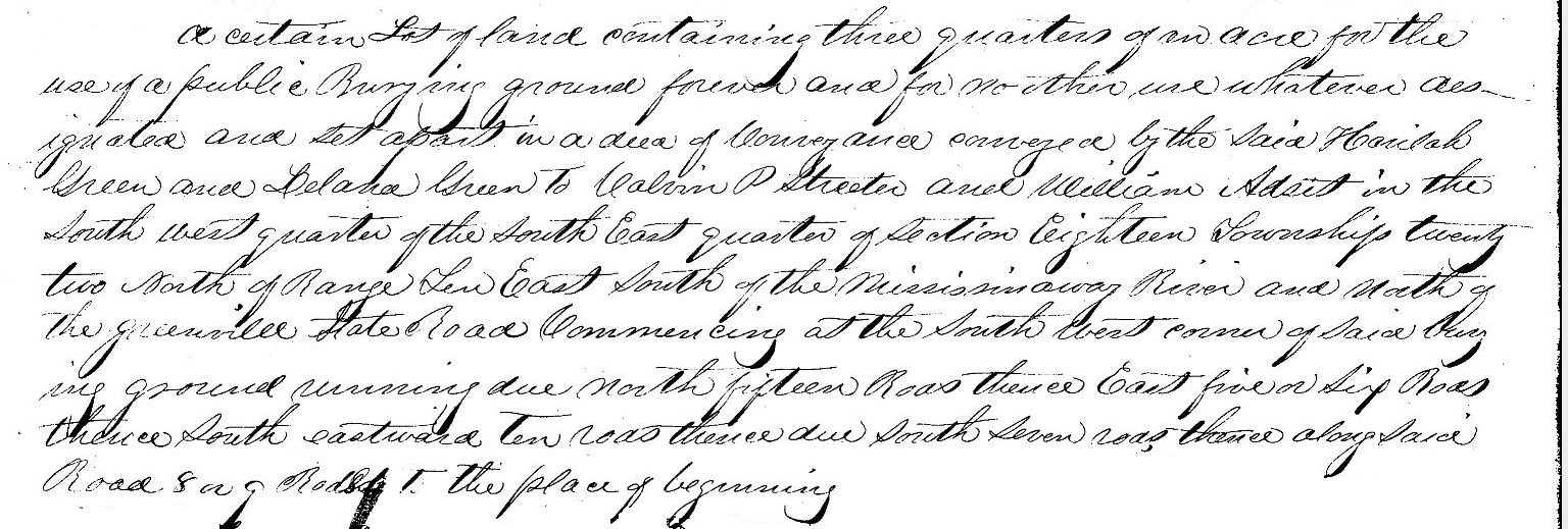
On 23 April 1851. Green donated "three quarters of an acre for the use of a public burying ground forever
and for no other use whatever..." to County Commissioners David Shoemaker, Charles Mansfield and Joseph
Thomas "and their successors in office forever..." The description of the cemetery itself is spelled out as
"commencing at the south west corner of said burying ground running due north fifteen rods [247.5 feet]
thence east five or six rods [82.5 to 99 feet] thence south eastward ten rods [165 feet] thence due south
seven rods [115.5 feet] thence along said road 8 or 9 rods [132 to 148.5 feet] to the place of beginning"
in the west half of the southeast quarter of section 18, township 22, range 10. Not only are the
dimensions not very exact, there is no landmark other than the corner of the cemetery itself from which
to start.
Legal Decription from Deed
Havilah Green to County Commissioners, 1851
The cemetery is mentioned again in a deed on 12 March 1853 as being excepted in the sales of surrounding
land whe Adsit sold to Jesse Nixon. The description was taken verbatim from the Green to Streeter and
Adsit deed of 1851. Jesse died in 1904 and left all of his real estate to his son George with no
descriptions provided. At the time of George's death in 1913, he left the northern portion of the "Home
Farm" which would have included the cemetery to son Jesse Earl Nixon.
In 1876, the cemetery appears on the Baskin, Forster and Co map of Delaware County. It is shown on the
north side of the road just after it curves from due east-west to a northwest heading. Although these
historic maps are not always exact, it seems to sit in the area described in the deed, the west half of
the south east quarter.

Baskin, Forster and Co map of Delaware County, 1876
The last known sighting of the cemetery itself was a visit by Eli Rigdon and Dick Greene in 1948. Greene
described the scene in his "Seen and Heard in our Neighborhood" column in The Muncie Star on
October 18 of that year as making their "way among the tall dead weeds, cockleburrs, sticktights and
charging through a gully made when gravel was dipped many years ago. Climbing a knoll overlooking a
ravine, we came to what once was, and I suppose for that matter still is, a cemetery. There wasn't a
single marker, not a sign of one standing or lying on its back covered by earth or vegetation." He went
on describing it as "A small area enclosed by a ramshackle wooden fence once was a spot revered by
someone. Now only trees and not a slab rear from the ground." Rigdon claimed "There were some markers
here a few years ago...I don't know what happened to them."
In the early 1970s, Lillian Charlotte (Parsons) Nixon, daughter-in-law of George and widow of Jesse Earl
Nixon, was living in the elder Jesse Nixon's home on the south side of Eaton-Wheeling Pike. She not only
had knowledge of the existence of the cemetery, but recalled a tombstone there for a Revolutionary War
soldier. At the time of her recollection, the cemetery's exact location was no longer identifiable, and
to date, has not been found. She and Jesse Earl married in 1923. Had there been a burial there after
that, she might have remembered it. Additionally, had remains been removed to Mount Zion Cemetery, as
some claim, one would think she might have recalled that as well. That being said, it is hard to find
fault in what a 70 year old woman leaves out of a random discussion.
Based on the limited information available, we can discern that the cemetery was established some time
between Green's acquisition in 1833 and and 1851 when the surrounding property was sold and the cemetery
was transferred to the county officials. We know it was already in use by 1851 since the deed from that
year states "which is now used and intended for a burying ground" That aligns with Mrs Nixon's
claim of a Revolutionary War veteran's burial. A young colonist (assuming he was not serving the British
king) would have been born in 1767 (making him 16 at the end of the war in 1883). That would make him 66
years or older in 1833 and 88 in 1851. It would not be unreasonable to think Green buried his own family
members on the land. The 1840 Delaware County census indicates that living in Green's home is a man born
1781 to 1790 and a woman born 1771 to 1780. If the numbers are precise, this male is unlikely to have
served in the Revolutionary War, but he and the woman may well have been interred on the family property.
Neither age fits Delana's parents, although her father was a Revolutionary War veteran. Havilah's father,
a War of 1812 veteran, is buried in Granville and his mother is likely buried in Ohio.
It seems unlikely the names of anyone buried in this cemetery will ever be discovered. The same goes for
its precise location.
© On The Banks of White River, Jennifer Lewis, 21 March 2025
