STRASBURGH AND STRASBURG
Answers and Questions
Coonrod Mutter (spelled variously as Coonrod, Cunrod, Conrad, Mooter, Muter, Mutter), a German immigrant "of Delaware County, Indiana", received a land patent in Delaware County in November of 1830. While that parcel has no connection to Strasburgh, our topic, it shows that Mutter was established in the area by that time. He seems to have had at least eight children, some belonging to first wife Caroline and the rest with second wife Mary.
On March 16, 1833, Elijah and Anna Casteel sold two pieces of real estate to Coonrod. The land was described as the northwest quarter of the southeast quarter of Section 18 Township 21 Range 10 as well as the southwest quarter of the northeast quarter of the same section and sold for $120.
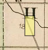 Location in Section 18
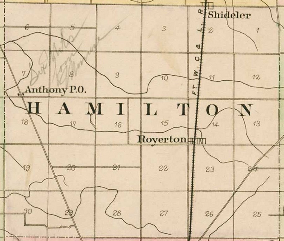
This 80 acres is just south of the settlement of Anthony on Wheeling Pike. Later generations would know this property at the Stradling Farm which tells you how well Mr Mutter's vision worked out.
Township 21 Range 10
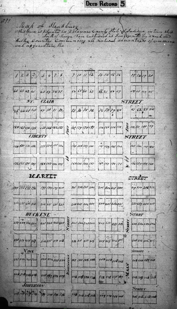
[1887 Delaware County Atlas, Griffing, Gordon & Company]
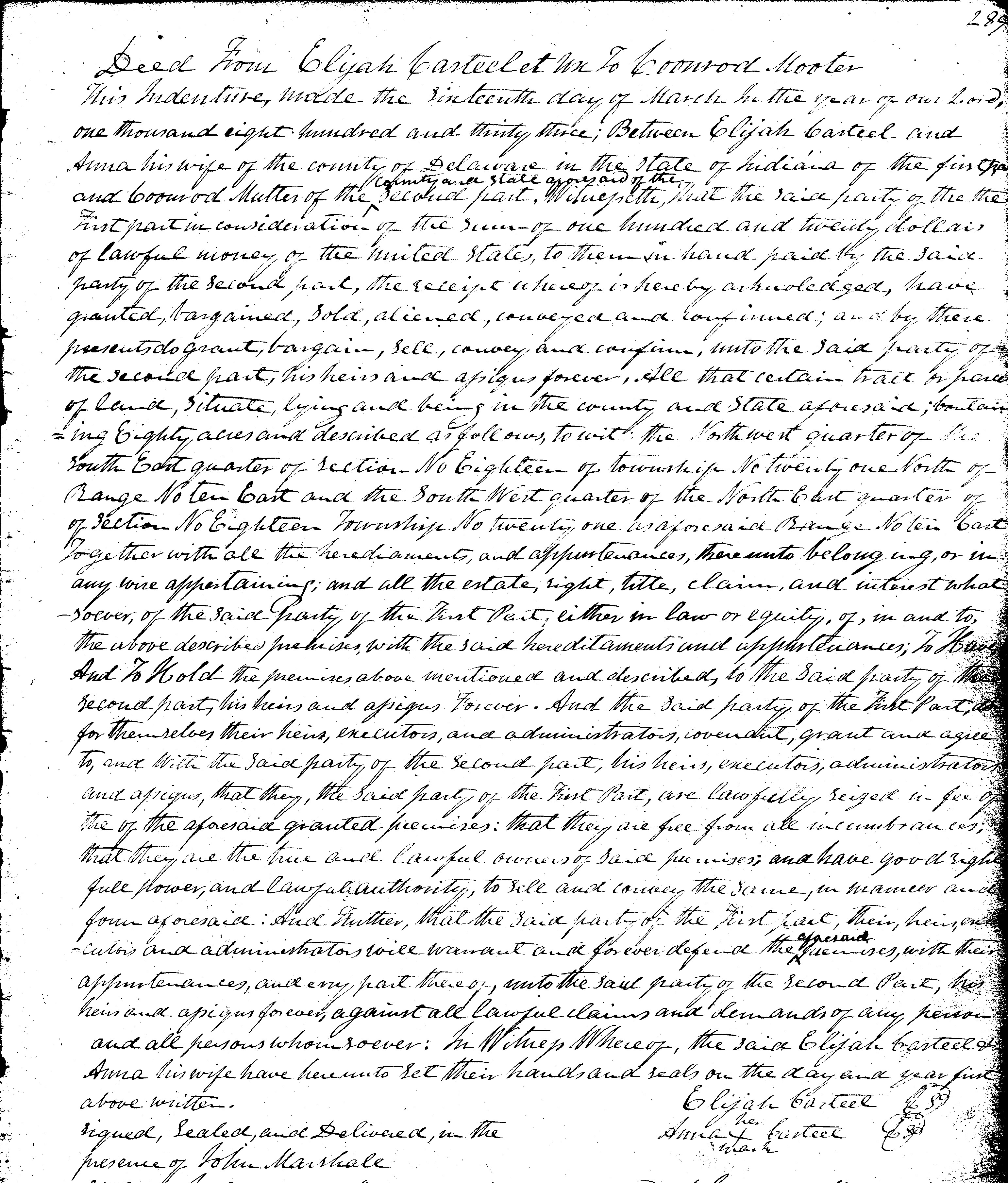
Casteel to Mutter Deed
[Muncie Public Library, Local History & Genealogy Collection]
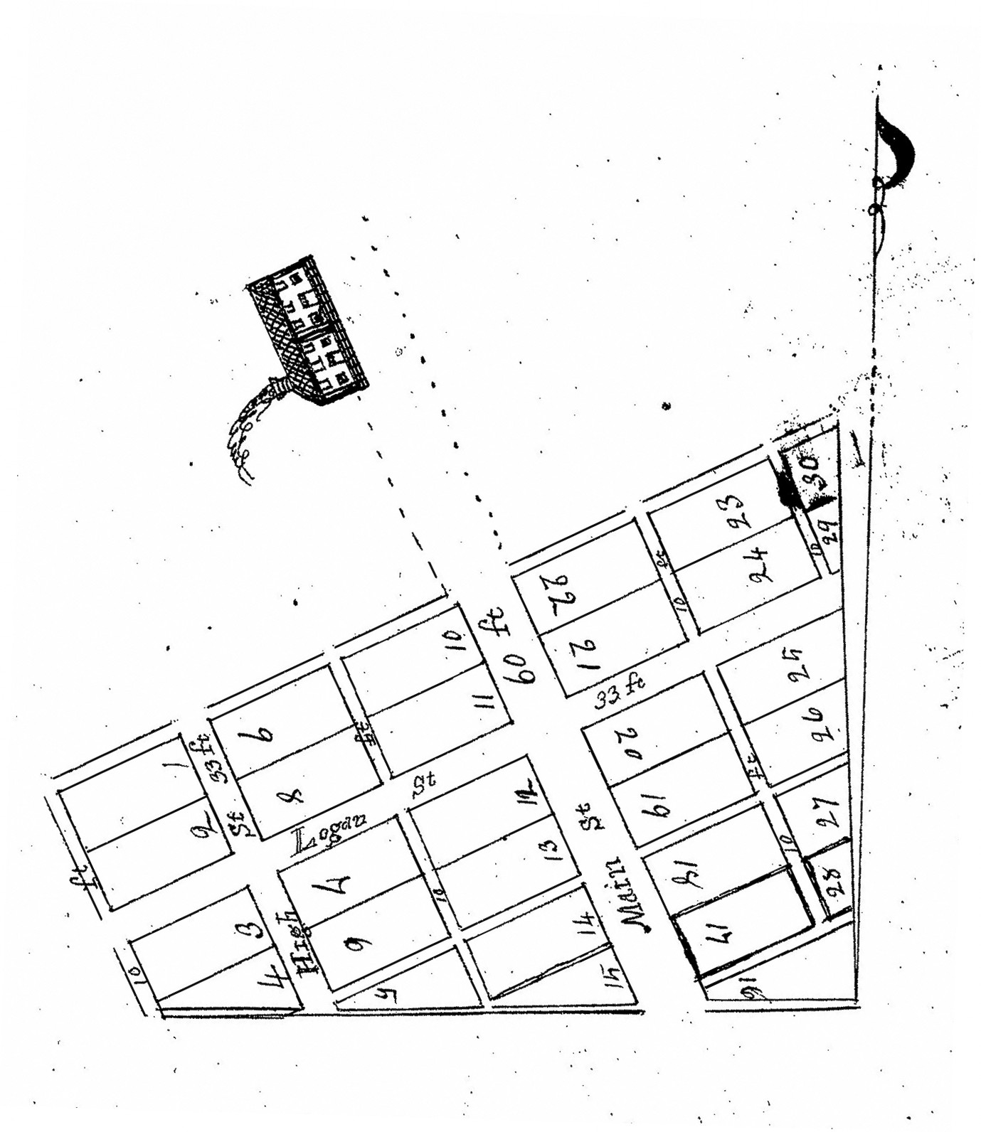
It is unclear what his immediate plans were for the second parcel, but plans for the first piece came to light a few years later. On 20 February 1839, Mutter filed a plat map of a new town, Strasburgh. Lying on both sides of Wheeling Pike in the Northwest quarter of the Southeast quarter 18 21 10, the town was laid out on the axis of the road rather than a North-South orientation. Main Street, a massive 60 feet in width (modern two-lane roads are about 24 feet), ran southeast to northwest on the existing Wheeling Pike. High Street, parallel to the west, was 33 feet wide. The only cross street, Logan, was also 33 feet. The awkward layout of town resulted in 10 of the 30 lots to be oddly shaped polygons or fractional lots. The 20 standard lots in the new town would be 66 feet wide fronting on the main streets and 132 feet in depth.
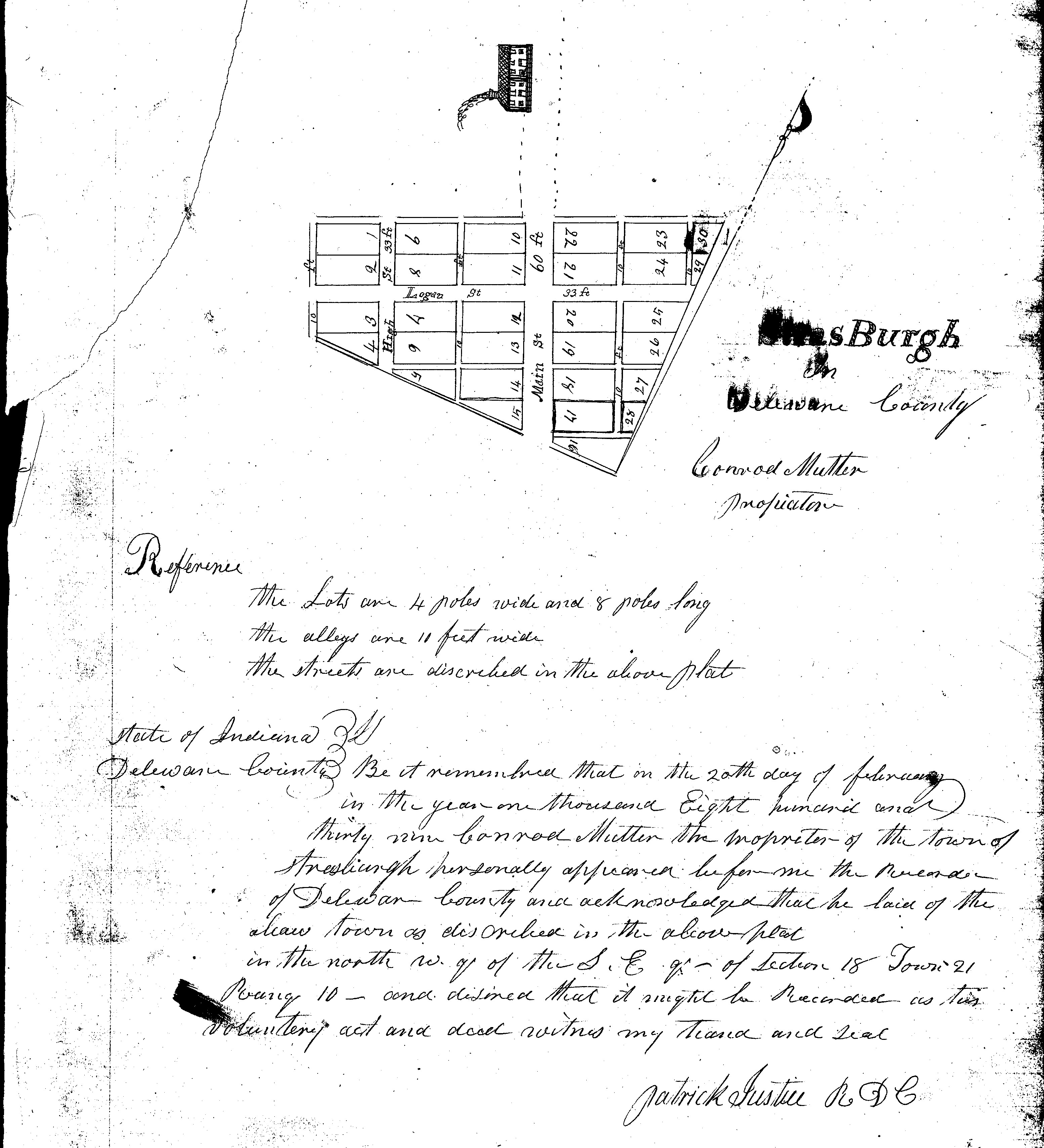
Strasburgh Map
[Muncie Public Library, Local History & Genealogy Collection]
The plat also showed a structure along Main Street, or Wheeling, to the north of the town on the west side of the road. It was a commanding two-story structure in two sections divided in half by a breezeway with a door centered in each half. There was a window on each side of each door as well as three upper windows in each section. It is not clear whether this building was pre-existing or part of the plan. An 1887 township map shows a structure at that approximate location, albeit forty-eight years later.
In March of 1840, Mutter sold two lots each to Abraham and John McConnell. Abraham received full lot 14 and odd lot 5 for $17.62. Those lots were back to back divided by an alley. John gave $13.62 for full lot 9 and odd lot 4. These two lots were down High Street and on opposite sides of the road from each other. When looking at the map, 4 is across the street from 6, but the numbers for one side of the street are upside down in comparison to the other making me wonder if John did not intend to buy 4 and 6 rather than 4 and 9. Why one paid more than the other is unknown.
On December 15, 1840, Mutter liquidated most of his remaining Strasburg assets when he sold all of the property purchased from the Casteels
to Jeremiah Howell. The deal did not include lots 4, 5, 9, 13, 14, 16, 17, 18, 28, and 29, a mix of regular and fractional lots said to have
already been sold by Mutter. Lot 18 was sold for $12 to the school system for the use of public education in September of 1844. Plans were
likely already underway for this deal prior to the sale to Howell since it was listed as one of the exceptions. The buyers of the other claimed lots, 13, 16, 17, 28 and 29 are thus far unknown. Howell would later sell that same land to Samuel P Anthony.
 North/South Orientation of Plat
Recalling a trip through the area in June of 1845, an essayist known only as "Graybeard" recalled for the Muncie Daily News in July of 1885,
that "Old Mutter, or Mooter's, tavern was the only sideshow in that mudhole" that was Wheeling Pike between Munseytown and the burg of
Wheeling. He made no mention of any actual settlement having been established there.'
Local folklore passed down through area resident and Civil War veteran Sam Reed to later landowner William Danner stated that Mutter's wife was found in a well and Conrad was a suspect.
He was taken by a group of vigilantes to an area in the southwestern part of the county, tied to a tree and tagged with a note warning him to leave town. He left town soon after, never to be heard from again. Only one part that story was actually was true. Mutter left the area. Eventually. But there is no indication that he left under any sort of durress.
In the 1850 census, Coonrod and his family found themselves in Mercer County, Missouri where he received a patent for land in
1859. Coonrod died there in December of 1864 and is buried with the surname spelling "Mouter" in Goshen Cemetery in Princeton, Mercer County,
Missouri. But what about Mary? She did, in fact, precede Coonrod in death, but only by four months. She died in July, 1864, and is buried in
the same cemetery as Coonrod and several of their other family members.
Mary wasn't somewhere in a well in Delaware County and Coonrod didn't ride off into the sunset never to be heard from again, so what more questions could there be?
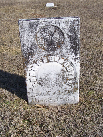 Grave of Coonrod Mouter, Goshen Cemetery, Princeton, Missouri
Find A Grave Memorial 14172269
[Find A Grave Contributors Phil & Kathi 6411871]
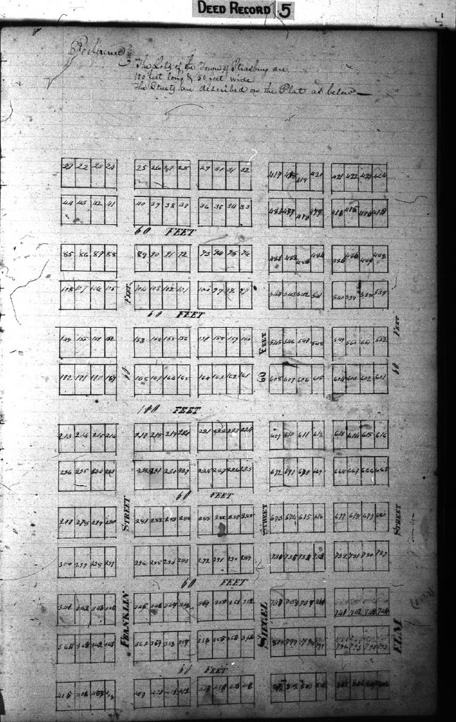
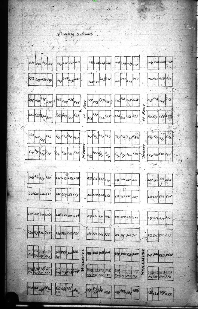
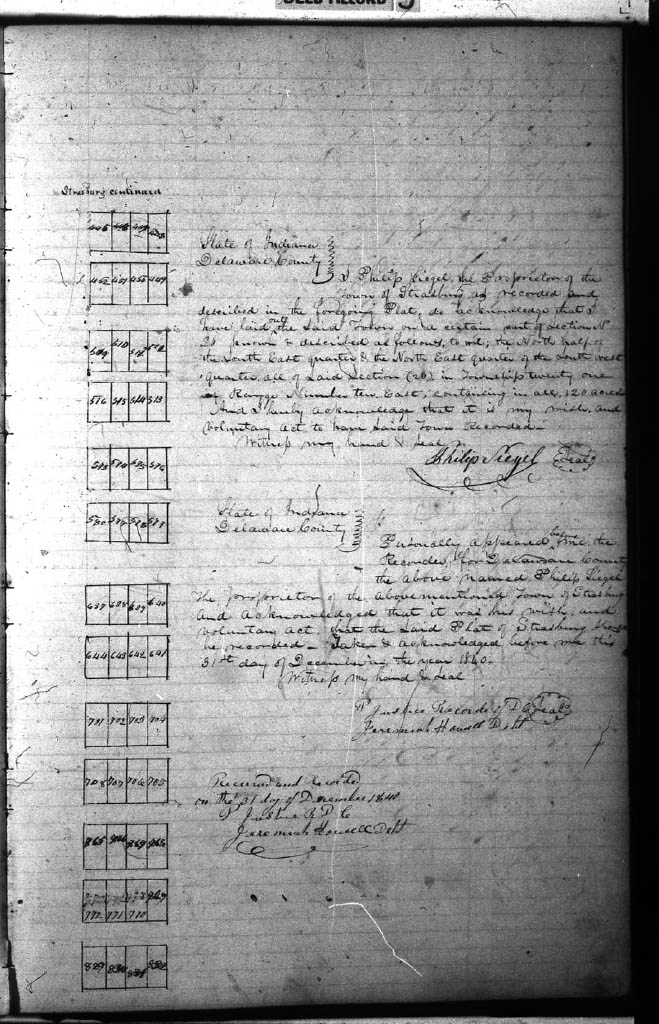
A baffling piece of the history puzzle presents itself as a second map designated as Strasburgh filed on December 31, 1840. Just 16 days after Mutter's dream of Strasburg effectively ended with the sale to Howell, Philip Seigel picket up the German gaunlet and registered his plat.
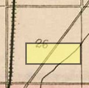 Location in Section 26
"I Philip Siegel, the proprietor of the Town of Strasburg as recorded and described in the foregoing plat, do acknowledge that I have laid out the said town on a certain part of section No 26 known and described as follows, to wit: the north half of the south east quarter & the north east quarter of the south west quarter, all of said section (26) in Township twenty-one of range number ten east containing in all 120 acres. And I hereby acknowledge that it is my wish and voluntary act to have said town recorded.
Witness my hand and seal
Philip Siegel"
Map Part 1
[Information and GIS Services]
Map Part 2
Map Part 3
Map Part 4
Despite buying and selling several properties in Delaware County between 1837 and 1841, Philip Seigel's biggest mark left behind was a series
of court cases for non-payment and real estate disputes. The last of thses was finally settled in 1847. Court records indicate that Seigel
was not a resident of Indiana at least in the later years, but lived for a period of time in Hamilton County, Ohio. He may have never
actually lived in Delaware County.
Unfortunately, Seigel's Strasburg was lost to history every more thoroughly than that of Mutter. Both towns, either dreams or schemes, faded into nothing more than dusty records.
©On The Banks Of White River/Jennifer Lewis, 26 February 2025
