Pittsburgh: The Little Town That Wasn't
Following the creation of Delaware County as well as the establishment of Muncie as the commerce and manufacturing center, little towns and villages popped
up all over the county hoping to cash in on the expansion. Elijah Collins and Havilah Green were early settlers in Union Township. Green received land there
as early as 1833 and Collins beginning in 1835. The two men laid out plans to establish a town on the southwest bank of the Mississinewa River that runs through
Section 20, Township 22 North, Range 10 East. The plans called for Pittsburgh to be situated at the intersection of what is now North County Road 200 West and
Eaton-Wheeling Pike, taking up both the southwest corner of the intersection lying in section nineteen belonging to Green and southeast corner of the intersection
owned by Collins in section twenty.
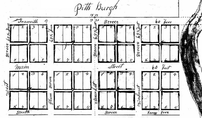
Each man retained ownership of his half of the eight-block town when they filed the plat map on July 26, 1837. The northern boundary was the line between sections
nineteen and twenty on the south side and seventeen and eighteen on the north, referred to on the map as Granville Street. This was later known the Greenville State
or Greenville-to-Marion Road, now Eaton-Wheeling Pike. The two roads farther south were Main and South. North-south roads from the west were West, Plum, Market and
Walnut Streets. If drawn to scale, the far west end of town appears to have been right at the bank of the river.
Each city block was divided into quarters by a twelve foot wide alley. Each quarter contains two sixty by one hundred thirty-two foot lots. The
north-south streets were forty-nine and a half feet wide. Granville and Main were sixty feet while South was only forty, apparently because the land further south
was not developed. From August of 1837 through March of 1838, Havilah and Delana Green sold six lots while Elijah and Mary Collins sold at least five.
Whether still optimistic about the future of the town, or just appearing to be, Green sold a parcel of land to the Union Township School District
Number Four on August 4, 1838. In the year prior, school had been conducted in a cabin on Green’s property with instruction by Robert Wharton, but that site was
farther west and was in section nineteen. The new location was in section eighteen was described as being in the east half of the southeast quarter and "...beginning
about twenty rods [330 feet] west of the town of Pittsburgh it being on the north side of the state road leading from Greenville to Marion and about four rods [66
feet] west of said Havilah Green's spring thence west eight rods [132 feet] thence north four rods thence east eight rods thence south four rods back to the place of
beginning..." There is no indication that there was ever a school built in the site on the north side of the road. The ruins of a red brick school house remains on
the southwest corner of C. R. 200 W. and Eaton-Wheeling Pike are of much later construction and have no connection to the town of Pittsburgh itself.
Although the precise timing is unclear, a cemetery was established near the site of Pittsburgh. Havilah Green acquired his property in section eighteen
by a patent issued in 1833. The cemetery was described in a deed transferring it from the Greens to "...David Shoemaker, Charles Mansfield and Joseph Thomas, County
Commissioners of Delaware County and State of Indiana, and their successors in office forever…three quarters of an acre for the use of a public burying ground forever
and for no other use whatever..." in 1851. The description of the cemetery itself is spelled out as "commencing at the south west corner of said burying ground running due
north fifteen rods [247.5 feet] thence east five or six rods [82.5 to 99 feet] thence south eastward ten rods [165 feet] thence due south seven rods [115.5 feet]
thence along said road 8 or 9 rods [132 to 148.5 feet] to the place of beginning" in the west half of the southeast quarter of section 18, township 22, range 10. Not
only are the dimensions not very exact, there is no landmark other than the corner of the cemetery itself from which to
start. The cemetery is mentioned again in a deed in 1853 as being excepted in the sales of surrounding land. In the early 1970s, Lillian Charlotte (Parsons) Nixon,
widow of Jesse Earl Nixon who was the nephew of 1853 grantee Jesse Nixon, living at that time in the elder's home on the south side of Eaton-Wheeling Pike,
not only had knowledge of the existence of the cemetery, but recalled a tombstone there for a Revolutionary War soldier. At the time of her recollection, the cemetery’s
exact location was no longer identifiable, and to date, has not been found. The last known sighting of the cemetery itself was a visit by Eli Rigdon and Dick Greene in 1948.
Greene described the scene in his "Seen and Heard in our Neighborhood" column in The Muncie Star on October 18 of that year as "A small area inclosed by a ramshackle wooden fence
once was a spot revered by someone. Now only trees and not a slab rear from the ground." Rigdon claimed "There were some markers here a few years ago...I don't know what
happened to them."
It isn't clear why, but the time came when it was obvious that the plans for Pittsburgh had failed. Was there nothing to draw people to the little
town? A mill appears nearby in records two decades later but it is unclear if there was one, or anything for that matter, nearby to entice settlement in 1837 or
1838. Could the proximity to the Mississinewa River have threatened or even flooded the town site? The location shown on the plat map is incredibly close if it is,
in fact, to scale. Elijah and Mary Collins bought back at least some of the lots on their end of town in late 1838 and 1839. Havilah and Delana Green did not buy
back the lots they had sold. In 1851, Green sold the property surrounding the cemetery and the remants of his Pittsburg dream excluding sit town lots owned by others
to Calvin Streeter and William Adsit. With no structures surviving (had any been built at all) and the loss of the cemetery, the town left behind little
proof beyond a paper trail. Pittsburgh has gone down in history as a little town that wasn’t.
© On The Banks Of White River/Jennifer Lewis 2014
[This article appeared is a slightly edited form in the Delaware County (Indiana) Historical Society Newsletter, January/February, 2015
Updated 6 April 2019, 19 March 2025]

Live Stats For Website